Regional Management Units
Background
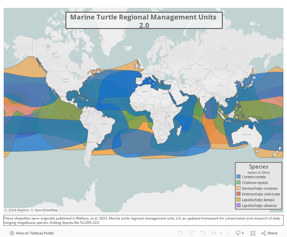
Regional Management Units were updated in 2023 in a paper entitled Marine Turtle Regional Management Units 2.0: an updated framework for conservation and research of wide-ranging megafauna species using participatory GIS. The boundaries, originally published in 2010 as a part of the 6th Burning Issues Workshop, incorporate expert knowledge and expanded and improved data and are therefore more refined and more accurately represent sea turtle populations.
RMUs were developed using nesting sites, satellite telemetry, genetic stocks (MUs), and expert knowledge to fill the need for a globally consistent, biologically relevant framework for defining marine turtle populations below the species level and above individual stocks or rookeries. RMUs have allowed conservation efforts to focus population evaluations and conservation action at a more useful scale than the species level, which, for migratory, geographically widespread, long-lived animals such as marine turtles caused a slew of complications and debates. The IUCN has adopted RMUs for red list assessments and has been cited widely within and beyond the marine turtle literature.
Methodology/Principal Findings
The work presented in Wallace et. al 2023 is a culmination of expert knowledge and collaboration and the most up-to-date information on sea turtle biogeography and genetics. Thanks to these grand efforts, the boundaries for RMUs are now significantly more accurate and refined compared to the original RMUs published in 2010 and will aid in sea turtle research, conservation, and management.
This process involved:
Collating 279 papers pertaining to sea turtle biogeography and genetics
Georeferencing 959 maps and 167 distinct genetic stocks
Creating a custom, interactive GIS platform for collecting edits and feedback from 49 global experts
Writing and publishing a peer-reviewed article featuring 48 updated RMU boundaries (see below)
Conclusions/Significance
The RMU framework is a solution to the challenge of how to organize marine turtles into units of protection above the level of nesting populations, but below the level of species, within regional entities that might be on independent evolutionary trajectories. Among many potential applications, RMUs provide a framework for identifying data gaps, assessing high-diversity areas for multiple species and genetic stocks, and evaluating the conservation status of marine turtles. Furthermore, RMUs allow for the identification of geographic barriers to gene flow, and can provide valuable guidance to marine spatial planning initiatives that integrate spatial distributions of protected species and human activities. In addition, the RMU framework – including maps and supporting metadata – will be an iterative, user-driven tool made publicly available in an online application for comments, improvements, download and analysis.
Open Access Tools & Resources